Sign In | Join Free | My himfr.com
Home > Inertial Navigation System >

High Heading Accuracy 0.1° GNSS Integrated lnertial Navigation System for Marine Navigation

Shenzhen Fire Power Control Technology Co., LTD
Trust Seal
Verified Supplier
Credit Check
Supplier Assessment
Contact Now
    Buy cheap High Heading Accuracy 0.1° GNSS Integrated lnertial Navigation System for Marine Navigation from wholesalers
     
    Buy cheap High Heading Accuracy 0.1° GNSS Integrated lnertial Navigation System for Marine Navigation from wholesalers
    • Buy cheap High Heading Accuracy 0.1° GNSS Integrated lnertial Navigation System for Marine Navigation from wholesalers
    • Buy cheap High Heading Accuracy 0.1° GNSS Integrated lnertial Navigation System for Marine Navigation from wholesalers

    High Heading Accuracy 0.1° GNSS Integrated lnertial Navigation System for Marine Navigation

    Ask Lasest Price
    Brand Name : FIREPOWER
    Model Number : INS500D
    Price : 7000$
    Payment Terms : L/C,T/T,Western Union
    Supply Ability : 500/month
    Delivery Time : 1 week for sample
    • Product Details
    • Company Profile

    High Heading Accuracy 0.1° GNSS Integrated lnertial Navigation System for Marine Navigation

    Product Description


    The INS500D fiber - optic integrated navigation system is a cost - effective solution. It is built upon a closed - loop fiber - optic gyroscope, an accelerometer, and a high - end GNSS receiving board. Through multi - sensor fusion and advanced navigation calculation algorithms, it meets the demands for precise measurement of attitude, heading, and position information in medium - to - high - precision mobile measurement systems and large - scale UAV applications.


    This system supports two operation modes: inertial/satellite integrated navigation mode and pure inertial mode.


    Inertial/Satellite Integrated Navigation Mode:
    In this mode, the GNSS receiver utilizes the received satellite positioning information for integrated navigation. It can output information such as the carrier's pitch, roll, course, position, speed, and time. In case of signal loss, it switches to outputting position, velocity, and attitude data calculated through inertial means. The pitch and roll measurements remain accurate. There is also a short - term course - keeping function, along with short - term meter - level positioning accuracy. Additionally, in the integrated navigation mode, post - processing information can be provided for use by post - processing software.


    Pure Inertial Mode:
    Once the pure inertial mode is initiated (meaning that GPS fusion has not occurred since power - on; if it loses lock after prior fusion, it reverts to the integrated navigation mode), the system offers an accurate attitude measurement function. It can output pitch, roll, and heading data. Moreover, in the pure inertial mode, the system is capable of static north - finding.


    Technical Parameters

    Parameter

    Technical indicators

    Position accuracy

    Single point (RMS)

    1.2m

    RTK(RMS)

    2cm+1ppm

    Lock-loss

    accuracy (CEP)

    1.8nm/h

    2 ‰ D, where D is the distance travelled (optional, DVL or odometer combination)

    Heading (RMS)

    Self-north seeking accuracy

    0.1 ° × sec (Lati), 10 min alignment of stationary base; Where Lati denotes the latitude.

    Lock-loss holding accuracy

    0.1°/h

    Attitude (RMS)

    GNSS is valid

    0.02°

    Lock-loss holding accuracy

    0.05°/h

    Horizontal Velocity Accuracy (RMS)

    Single point L1/L2

    0.1m/s

    GNSS is invalid

    2m/s/h

    Navigation data frequency

    200Hz

    Gyroscope

    Range

    400°/s

    Zero bias stability

    0.3°/h

    Scale factor nonlinearity

    50ppm

    Angular random walk

    0.02°/ √hr

    Accelerometer

    Range

    16g

    Zero bias stability

    50ug⑤

    Scale factor nonlinearity

    100ppm

    Speed random walk

    0.01m/s/ √hr

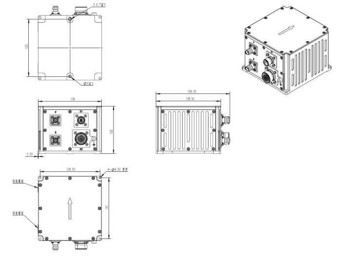
    Physical dimensions and electrical characteristics

    Overall dimensions

    138.5 mm× 136.5 mm×102mm

    Weight

    2.0 kg (without cable)

    Input voltage

    12~36VDC

    Power consumption

    < 24W (steady state)

    Store

    16G

    Environmental indicators

    Operating temperature

    -40℃~+60℃

    Storage temperature

    -45℃~+70℃

    Random vibration

    6.06g,20Hz~2000Hz

    MTBF

    3000h

    Interface characteristics

    PPS, EVENT, RS232, RS422, CAN (optional)

    100m network port

    Antenna Connector (TNC)

    Wheel speed sensor interface


    Outline Drawing

    Quality High Heading Accuracy 0.1° GNSS Integrated lnertial Navigation System for Marine Navigation for sale
    Inquiry Cart 0
    Send your message to this supplier
     
    *From:
    *To: Shenzhen Fire Power Control Technology Co., LTD
    *Subject:
    *Message:
    Characters Remaining: (0/3000)